The Montgomery Bell Trail is the park’s long walk—the route for hikers who want the hardwood ridges, creek bottoms, lakes and history to unfold over hours rather than minutes. Tennessee State Parks lists the trail at 10.24 miles. That distance makes it a serious day hike even though the terrain never becomes mountainous.
Why hike it
This is the closest thing Montgomery Bell has to a full portrait. The trail reaches old ore country, passes water and wetland habitat, crosses working park roads and ties into shorter trails. Much of the pleasure is quiet rather than theatrical: a long ridge under oak and hickory, the sound of a creek returning after a dry slope, the sudden openness of a lake edge.
Route character
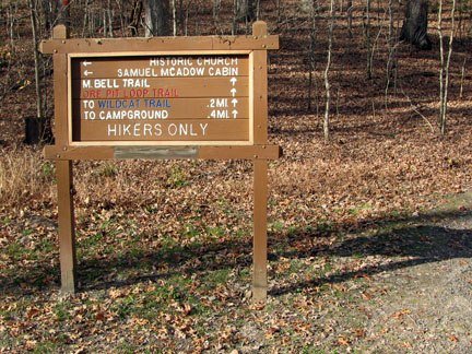
The circuit is connected to the Spillway, Creech Hollow, Wildcat, Ore Pit and Woodland Shelter routes. That web creates useful alternatives, but it also makes a current map essential. Expect roots, rocks, leaf-covered tread, intermittent creek crossings and several places where a hurried hiker can follow the wrong blaze. Historic route descriptions are helpful context, not a substitute for signs on the ground.
Day hike or overnight?
Strong hikers can complete the circuit as a day hike with an early start and conservative pace. Anyone planning to stay overnight must confirm the current shelter, permit, reservation, camping and water rules with the park. Read our overnight planning guide before treating this as a backpacking trip.
Navigation
- Carry the current official map and photograph the trailhead map.
- Download an offline map, but do not make a phone your only navigation tool.
- Pause at every junction and road crossing until the next blaze is certain.
- Do not improvise shortcuts on old roads or social paths.
Water, weather and timing
Natural water must be treated, and a mapped stream may be low or dry. Carry enough capacity for the season and confirm current guidance. Summer heat and humidity can make the mileage punishing; wet leaves and wooden surfaces can be slick; winter daylight is short. Turn around or shorten the route before a small problem becomes an after-dark navigation problem.
Highlights along the circuit
Depending on direction and current routing, hikers encounter the park’s iron-industry landscape, historic church area, forested natural-area tracts, creeks and lake margins. The trail is especially rewarding for hikers interested in how human history and recovering forest occupy the same ground.
Who should choose another trail
Families with small children, visitors with limited time and anyone uncertain about a ten-mile natural-surface route will enjoy the park more on Jim Bailey, Ore Pit or Creech Hollow. There is no prize for choosing the longest trail.
Before leaving the trailhead
- Tell someone your route and return time.
- Carry water, food, rain protection, first aid and a dependable light.
- Check official alerts and ask about recent blowdowns or high water.
- Keep dogs leashed and confirm current rules.
- Leave ore pits, structures, plants and wildlife undisturbed.
Return to the Montgomery Bell hiking hub to compare every major trail, or review our trail safety guide.
Sources
Distance and official trail status should be confirmed through Tennessee State Parks and the current park map. This guide avoids guaranteeing water, access or conditions that can change.